
| Rangamati Hill District রাঙ্গামাটি পার্বত্য জেলা(Bengali) |
|
|---|---|

Rangamati Hill District
|
|
| Coordinates: 22°38′N 92°12′ECoordinates: 22°38′N 92°12′E | |
| Country | |
| Division | Chittagong Division |
| District | Rangamati District |
| Government | |
| • Member of the Parliament from Rangamati Hill District | Dipankar Talukder |
| • Deputy Commissioner(D.C) | Saurendra Nath Chakrabhartty |
| • Chakma Raja (Chakma Circle Chief) | Debashish Roy |
| • Pouroshava Mayor | Habibur Rahman |
| Area | |
| • Total | 2,361.45 sq mi (6,116.13 km2) |
| • Land | 1,862.80 sq mi (4,824.63 km2) |
| • Water | 498.7 sq mi (1,291.5 km2) |
| Elevation | 49 [1] ft (14 m) |
| Population | |
| • Total | 508,182 |
| • Density | 210/sq mi (83/km2) |
| Time zone | BST (UTC+6) |
| • Summer (DST) | BDST (UTC+7) |
| Postal Code | 4500 |
| Area code(s) | 0351 |
| Website | http://www.dcrangamati.gov.bd/ |
| Poulation & Area related info taken from http://www.dcrangamati.gov.bd/ | |


Contents
Geography
Rangamati is located in the Chittagong Division. The total area of the district is 6116.13 sq km. It is bordered by the Tripura state of India to the north, Bandarban District to the south, Mizoram State of India and Chin State of Myanmar to the east, and Khagrachari and Chittagong Districts to the west.It’s a combination of Hill- Lake-Plain land The area of the district is 6116.13 km2 of which 1291.5 km2 is riverine and 4824.63 km2.is under forest vegetation and the lake area is about 650 km2.
Demography
The total population is 5,08,182 according to 2005 census of which tribal 52% and non-tribal 48%. The number of males is 2,87,060 and the females are 2,38,043 (Census 2001). The density of population is 83 per square kilometer (Census 2001). The number of household is 1,03,974 having the household size 4.8 (Census 2001). The total population is divided into Bangalees and eleven tribes (ethnic minorities): Chakma, Marma, Tanchangya, Tripura, Pankua, Lushai, Khiang, Murang, Rakhain, Chak, Bowm,Khumi.[2]Tribal population : (as per census of 2005 ):
Chakma-1,86,395, Marma-44,727, Tanchanga-18,607, Tripura-6,697, Pankho- 2,118, Bowm-1,053, khyang- 791, Lusai- 217, Chak- 177, Rakhain-70, Khumi-50,Gurkha-03,Etc.-174 [3]
As per 1991 census, the religious break up of the population of the district were: Buddhist 53.83%,Muslim 39.28%, Hindu 5.62% and Christian 1.12%. Religious institutions Pagoda 1230, Mosque 1059, Temple 65, Church 16. Genderwise, male constituted 53.59% and female constituted 46.41% of the population.[4]
Historical significance
- Rangamati was a contesting ground for the kings of Tripura and Arakan.This region came under the Mughal Empire after the Muslim invasion in 1566.[1]
- In 1737 Sher Mosta Khan,a tribal leader,took refuge with the Mughals. After this the Chakma settlement began along with various other settlements of varying ethnicity.[2]
- From 1760 to 1761,this land was leased to the East India Company.[3]
Rangamati Town
Rangamati Town is mainly divided into 13 areas. Namely Vedvedi, Collegegate, Rajbari, Newmarket, Banarupa, Kathaltoli, Fishery Ghath, Reserve Bazar, Launch Ghath, Pathor Ghata, Tabalchori, Mazher Basti, Asam Basti.- For the Town, see Rangamati.
Administration
Deputy Commissioner (DC): Md. Mostafa Kamal [5]Chairman of Zila Porishod: Nikhil Kumar Chakma
Chakma king: Barrister Debashish Roy wangza [6]
Education System
Rangamati district has an average literacy rate of 36.5%; male 45.8% and female 24.7%. There are 291 government primary schools, 120 non-government primary schools, 22 junior schools, 6 government high schools, 45 non-government high schools, 2 government colleges, 13 non-government colleges, 61 madrasas and 7 technical schools located throughout the district.Subdivisions
The district of Rangamati consists of 10 upazilas, 1 municipality (9 wards and 35 mahallas), 50 union parishads, 162 mouzas and 1347 villages.List of upazilas and unions in Rangamati District
- Rangamati Sadar Upazila
- Balukhali
- Bandukbhanga
- Jibtoli
- Kutukchari
- Mogban
- Shapchari

- Belaichhari Upazila
- Bilaichari Sadar
- Farua
- Kengrachari

- Bagaichhari Upazila
- Baghaichari
- Bangaltali
- Khedarmara
- Marishya
- Rupakari
- Sajek
- Sarbotali

- Barkal Upazila
- Aimachara
- Baraharina
- Barkal
- Bhushonchara
- Subalong

- Juraichhari Upazila
- Bonjugichara
- Dumdumia
- Jurachari
- Moydong
- Rajasthali Upazila
- Bangalhalia
- Gainda
- Ghilachari
- Langadu Upazila
- Betbunia
- Fatikchari
- Ghagra
- Kolompati
- Adarakchara
- Bhasonna Adam
- Boghachatar
- Gulshyakhali
- Kalapagazya
- Langadu
- Myanimukh
- Nannerchar Upazila
- Burighat
- Ghilachari
- Naniarchar
- Sabekkhong
- Kaukhali Upazila
Gallery
-
 Hill top house near the BDR Camp
-
 Lake Surrounded By Hills during Winter
-
 Sun Rays Through The Clouds
-
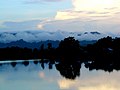 Clouds and Hills Beside Rangamati Lake
-
 Fishing Boat of the Rangamati locals
-
 Local Markets of Rangamati
-
 Local People using boats for transportation
-
 Buddhist Temple
-
 Tribal People
-
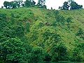 Green Grass Hills and Houses
-
 Shuvolong Waterfall
-
 A hanging bridge in Rangamati


Industry
- The economy of Rangamati is hugely dependent on agriculture with a total of 41.94% of the population employed there. Other occupational percentages are: agricultural labourer 12.06%, wage labourer 4.95%, commerce 8.22%, service 13.04%, fishing 2.02%, industry 4.57%, forestry 3.2% and others 10%. A grand total of 12275 hectares of land is used for cultivation,producing food and non food crops such as rice, potato, corn, mustard seed, cotton and jute among others. Fruits such as mango, jackfruit, banana, pineapple, litchi, black berry are also grown in Rangmati.
- Notable cottage industries of Rangamati are weaving, blacksmithing and wood work.Weaving is particularly famous for their woolen and jute rugs and hand loom cloth.
- Major industries include Chandraghona paper and rayon mill, Plywood Factory, Ghagra Textile and a Satellite Station at Betbunia amongst many others, producing and exporting goods.[4]
Places of interest
- Kaptai has Bangladesh's only hydro-electric project. The Kaptai Dam on the Karnaphuli River created for this purpose resulted in the Kaptai Lake.
- Tourist spots include the Hanging Bridge over the Kaptai Lake,the remnants of the residence of Raja Harish Chandra Roy,archeological relics and heritage such as the Palace,Mosque and Dighi of Raja Jan Bashk Khan.
- Cruising on the Kaptai Lake is an enjoyable way of observing the landscape as many great picnic spots, natural landmarks and historic monuments are accessible only by motorboats.The Rangamati Parjatan offers such tours to the tourists, taking them to great sights, locations of cultural and historical significance while explaining the diversity that exists in this district.
- There are several waterfalls in the hill tracts adjoining the lake,more prominent during the monsoon because of the increased water levels due to rainfall.
- Scattered throughout the district,are beautiful Buddhist temples and ancient relics of civilizations,all accessible by motor vehicles.