| Magura মাগুরা |
|
|---|---|
| District | |
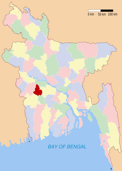
| Location of Magura in Bangladesh | |
| Coordinates: 23.40°N 89.40°ECoordinates: 23.40°N 89.40°E | |
| Country | |
| Division | Khulna Division |
| Government | |
| Area | |
| • Total | 1,048.0 km2 (404.6 sq mi) |
| Population (1991) | |
| • Total | 811,160 |
| • Density | 770/km2 (2,000/sq mi) |
| Literacy rate | |
| • Total | 28.5% |
| Time zone | BST (UTC+6) |
| • Summer (DST) | BDST (UTC+7) |
| Website | Banglapedia Article |
Geography
Magura District (Khulna Division) with an area of 1048 km2, is bounded by Rajbari district to the north, Jessore and Narail districts to the south, Faridpur district to the east and Jhenaidaha district to the west.Administrative
Administrator of Zila Porishod: Syed Shariful Islam [1]Deputy Commissioner (DC): Shooshanto Kumar Shaha [2]
Subdivisions
Magura district has 4 upazilas. They are:| This Bangladesh location article is a stub. You can help Wikipedia by expanding it. |


